What Are LiDAR Ground Control Targets and Why Do They Matter?
A complete guide to LiDAR ground control targets — how they work, why placement matters, and how they validate accuracy across every survey mission.
 adam57
LiDAR technology has become one of the most powerful tools in modern surveying. It captures millions of precise distance measurements per second, building dense three-dimensional point clouds that reveal the shape of terrain, structures, and vegetation in extraordinary detail. But even the most sophisticated LiDAR system carries positional uncertainty, and that's exactly where ground control targets earn their place.
Understanding what these targets do, and why they matter, is essential for anyone serious about producing accurate, defensible spatial data.
What Are LiDAR Ground Control Targets?
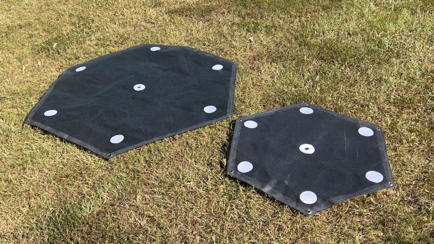
Ground control targets are physical markers placed at known, precisely measured locations on the ground before a LiDAR survey begins. They serve as spatial anchors, fixed reference points that tie your collected data to a verified real-world coordinate system.
Unlike standard photogrammetric targets used in drone photography, LiDAR targets are specifically designed to be detectable within a point cloud. They are typically:
-
High-contrast flat panels — usually black and white checkerboard or bullseye patterns
-
Retro-reflective materials — engineered to return LiDAR pulses with high intensity for easy identification
-
Geometric shapes with defined centers — allowing precise coordinate extraction during post-processing
Each target is surveyed using RTK GNSS or a total station before the flight or scan, giving it a known coordinate accurate to the centimeter or better. During processing, the software matches the scanned target positions to those ground-truth coordinates and adjusts the dataset accordingly.
How LiDAR Ground Control Targets Work
LiDAR sensors measure distance by emitting laser pulses and recording the time it takes for each pulse to return. The sensor's position and orientation, tracked by onboard GNSS and IMU, determine where each return point sits in three-dimensional space.
The problem is that GNSS positioning, even with corrections, carries small errors. IMU drift adds further uncertainty over long flights. These individual errors compound across a large dataset, producing a point cloud that may be internally consistent but globally misaligned by several centimeters or more.
The Role of Targets in Correction
When LiDAR ground control targets are distributed across the survey area, they give processing software identifiable features with known positions. The software compares the targets' locations in the raw point cloud with their actual positions on the ground, then applies a correction across the entire dataset.
This process, called georeferencing or registration, aligns the point cloud with the real world. The result is spatial data you can measure, model, and use to make decisions with confidence.
Why Ground Control Targets Matter
1. They Deliver Centimeter-Level Accuracy
Without reference targets, a LiDAR point cloud can carry horizontal and vertical errors of 5–15cm or more, depending on flight altitude, GNSS quality, and sensor grade. For applications like infrastructure inspection, mining volume calculation, or corridor mapping, that level of uncertainty is unacceptable.
Well-placed and accurately measured targets routinely bring total error down to 2–5cm, often better, giving you data that meets professional and regulatory accuracy standards.
2. They Enable Independent Accuracy Verification
Experienced surveyors always reserve a portion of their targets as checkpoint markers, which are not used in the georeferencing process but are checked against the final output to independently verify accuracy.
If the processed point cloud aligns with checkpoint coordinates within the required tolerance, the dataset passes quality control. If it doesn't, you catch the problem before it reaches the client. This turns accuracy from a claim into a documented, verifiable result.
3. They Support Multi-Session Data Consistency
Large survey projects are rarely completed in a single flight. Multiple sessions, different days, and changing GNSS conditions can introduce subtle misalignments between datasets. Reference targets provide a consistent spatial framework across every session, ensuring seamless alignment when the data is merged.
This matters especially for:
-
Construction progress monitoring is tracked over weeks or months
-
Topographic surveys covering large areas are flown in strips
-
Change detection studies comparing baseline and follow-up scans
4. They Strengthen Legal and Contractual Defensibility
Many infrastructure, mining, and land development projects require survey-grade accuracy backed by documented evidence. Using calibrated reference markers and reporting their residual errors creates a transparent accuracy trail from raw sensor data to a final deliverable that satisfies clients, regulators, and auditors alike.
Best Practices for Target Placement and Measurement
Getting the most from your reference markers comes down to placement strategy and measurement quality:
-
Distribute targets evenly across the full extent of the survey area, corners, edges, and center
-
Avoid clustering markers in one zone; uneven distribution degrades correction quality at the margins
-
Use retro-reflective targets for airborne LiDAR to maximize pulse return intensity and detection reliability
-
Measure each target with RTK GNSS or a total station to achieve sub-centimeter coordinate accuracy
-
Place targets on stable, flat ground away from vegetation, slopes, or surfaces that may shift
-
Reserve at least 20% of targets as independent checkpoints for post-processing validation
The targets themselves are low-cost. The accuracy and credibility they add to your deliverables are anything but.
Conclusion
LiDAR captures the world in stunning three-dimensional detail, but detail alone isn't accuracy. LiDAR ground control targets bridge the gap between raw sensor data and spatially verified, survey-grade output that professionals can trust and clients can act on.
Whether you're scanning a construction corridor, modeling a mining pit, or mapping floodplain terrain, properly placed and measured reference targets aren't a technical formality. They're the foundation that makes your data mean something.