

Exploring the Real-World Advantages of Wingtra Drones

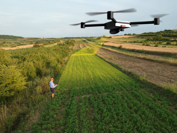
Drone technology has moved well beyond taking a few nice aerial photos. Today, businesses use unmanned aircraft to collect data, inspect land, map difficult areas, and make decisions that used to require a lot more people and equipment. This is where Wingtra Drones have started getting real attention. They’re built around a simple idea, really: collect accurate aerial data while making the work itself less of a headache.
That matters because fieldwork can be slow, expensive, and sometimes downright awkward. Getting people across large sites, dealing with rough ground, or trying to capture consistent survey data isn’t always easy. A capable drone can take some of that pressure off.
Why Wingtra Drones Stand Out in Field Operations
One of the biggest advantages is coverage. Traditional multirotor drones can be useful, but they often have limited flight times and need to spend more time in the air to cover bigger areas. Wingtra’s fixed-wing VTOL approach is different. The aircraft can take off and land vertically, then transition into efficient fixed-wing flight.
For surveying teams, that can make a noticeable difference. Instead of constantly moving equipment around a large project, operators can cover substantial ground in fewer flights. Less flying around also means less time spent charging batteries, preparing the aircraft, and repeating the same setup.
It’s not about making every job magically easy. No drone does that. But the workflow can become much more practical.
Better Mapping Without Sending People Everywhere
Surveying is one area where aerial technology really earns its keep. Construction sites, mines, farms, road corridors, and large parcels of land can be difficult to measure from the ground. There are areas that are steep, muddy, remote, or simply too large to walk efficiently.
A mapping drone can collect images and location data from above, giving teams a detailed picture of the site. This helps create orthomosaics, 3D models, elevation information, and other useful outputs.
The bigger benefit is consistency. When the same type of aerial data can be collected across a site, teams have something much more useful to work from than scattered measurements or old photographs.
And there’s a safety angle too. Workers don’t always need to enter every awkward corner of a site just to collect basic information. That alone can be a pretty big advantage.
Saving Time on Large Projects
Time is one of those costs people sometimes underestimate. A surveying crew may spend hours, or even days, walking through an area and collecting measurements. If the site is huge, that adds up quickly.
Wingtra Drones can help reduce some of that field time by covering large areas from the air. The data still needs to be processed and checked, of course. There’s no shortcut around good survey practices. But the collection stage can be considerably faster.
For companies working on multiple sites, this becomes even more useful. Getting crews in and out faster means they can move on to the next job sooner. That can affect project schedules, labor costs, and overall productivity.
It’s a fairly simple equation. Cover more ground, spend less time physically moving through it.
Useful Beyond Surveying
The applications don’t stop at mapping. Agriculture, infrastructure, environmental monitoring, quarrying and construction can all benefit from aerial data.
Farm operators, for example, can use aerial imagery to understand crop conditions and identify areas that may need closer attention. Infrastructure teams can document long corridors such as roads, railways or pipelines without sending inspection teams over every metre.
For environmental projects, repeated flights can provide a record of how an area changes over time. That’s useful when monitoring vegetation, erosion, land development or other changes.
The important thing is the data, not the drone itself. A drone is just the tool. What businesses really want is reliable information they can use.
Where UAS Hardware Makes a Difference
The quality of the aircraft and its onboard systems matters more than people sometimes think. Good UAS Hardware affects flight performance, image quality, positioning accuracy, endurance, and how smoothly the whole operation runs.
This is particularly important for professional surveying. You don’t want an aircraft that looks impressive but creates unreliable data. You need dependable sensors, navigation systems, and communication equipment working together.
That’s why choosing the right UAS Hardware should be part of the planning process, rather than something treated as an afterthought. The drone needs to match the job. A small site inspection and a large-scale mapping project don’t necessarily have the same requirements.
A Practical Investment for Modern Businesses
There’s an upfront cost involved with professional drone systems. That part shouldn’t be ignored. Operators may also need training, software, batteries, maintenance, and the right regulatory approvals.
Still, looking only at the purchase price misses the bigger picture.
If a drone reduces field hours, improves coverage, lowers the need for repeat visits, and gives teams better information, the investment can make sense over time. Businesses need to look at the entire workflow, not just the aircraft sitting in the case.
Wingtra Drones are particularly interesting for organizations that regularly deal with large areas and repeat mapping work. The more often the system is used, the easier it becomes to see where the return comes from.
Conclusion
The real advantage of Wingtra Drones isn’t simply that they fly. Plenty of drones fly. The useful part is how they can fit into real-world work where coverage, accuracy, and efficiency matter.
From surveying and construction to agriculture and infrastructure, aerial data can reduce unnecessary fieldwork and give teams a clearer view of what’s happening on the ground. When paired with dependable UAS Hardware, the technology becomes less of a novelty and more of a practical business tool.
That’s probably the best way to look at drones today. Not as gadgets, and not as replacements for every traditional method. They’re tools that can handle certain jobs faster and, in some cases, much more safely. When the job is right, that difference can be pretty significant.








Comments (0)